
City walk of Aubeterre-sur-Dronne
Aubeterre-sur-Dronne
© Office de tourisme du Sud Charente

© Les conteurs

© Office de tourisme du Sud Charente

© Les conteurs

© Les conteurs

© Les conteurs

© Office de tourisme du Sud Charente

© Les conteurs

© Office de tourisme du Sud Charente

© Office de tourisme du Sud Charente

2 Place du Champ de Foire
16390 Aubeterre-sur-Dronne
Departure altitude: 78 m
Aubeterre-sur-Dronne is a small village steeped in history, an ancient stronghold built in an amphitheater on the banks of the Dronne. "Alba Terra" unfolds its white houses with honey-colored tile roofs in a green setting. You will discover and be able to contemplate all along your walk historical and remarkable sites, religious buildings and panoramic points of view on the valley of the Dronne.
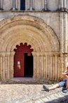
You will be able to admire its castle, the chapel of the Minimes as well as the court of the cloister, the church Saint-Jacques with its splendid Romanesque frontage, the tower of the apostles, the old hospice Saint-François, the wash-house on the place Merkes-Merval and finally the underground church Saint-Jean, the highest of Europe, known as "monolith", of 20 meters height, dug in the rock with its reliquary inspired by the Holy Sepulchre of Jerusalem Before returning to your starting point, take a break on the main square of the village, the Ludovic Trarieux square, born in 1840 in Aubeterre-sur-Dronne, founder of the French League for the Defense of Human and Citizen Rights.
A 3,5 km link allows you to join the circuit of the Fontaine du Loup in Bonnes.
On the itinerary


Positive elevation (ascent): 65 m
Negative elevation (descent): 59 m
Road surfaces
230 m on asphalt or tarred road
1.48 km on unknown surface in the Open Street Map database
65 m on rolling path (compacted sand, gravel, cobblestones)
Find this route on the Loopi mobile app
Scan the QR code, save it as a favorite, or start the guidance, just enjoy!


Scan the QR code, save it as a favorite, or start the guidance, just enjoy!
This route is provided by: Office de tourisme du Sud Charente
Be cautious and prepared during your outings. Loopi and the author of this sheet cannot be held responsible for any problems that occur on this route.